 XI Wiki


They'll live on in my memory
Sent from my SM-G900P using Tapatalk
- Navigation
+ Reply to Thread
Results 81 to 100 of 247
Thread: Hurricane Season 2018


-
2018-09-11 16:26 #81Cardiac Cat
- Join Date
- Nov 2006
- Posts
- 11,610
- BG Level
- 9
- FFXIV Character
- Airlea Ocelot
- FFXIV Server
- Balmung
- FFXI Server
- Bahamut
- WoW Realm
- Aegwynn

-
2018-09-11 16:26 #82BG Content
- Join Date
- Oct 2005
- Posts
- 62,960
- BG Level
- 10
- FFXIV Character
- Six Souls
- FFXIV Server
- Gilgamesh
- FFXI Server
- Quetzalcoatl
- WoW Realm
- Malorne
- Blog Entries
- 9


https://twitter.com/JPKassell/status...95639208538113
Up to 40 inches of rain predicted

Those models; Originally Posted by Gadritan


Worst case model has the hurricane sitting over NC for 36 hours.
Edit: Animated WC Model - https://twitter.com/RyanMaue/status/1039600615972917250
-
2018-09-11 16:34 #83BG Content
- Join Date
- Oct 2005
- Posts
- 62,960
- BG Level
- 10
- FFXIV Character
- Six Souls
- FFXIV Server
- Gilgamesh
- FFXI Server
- Quetzalcoatl
- WoW Realm
- Malorne
- Blog Entries
- 9
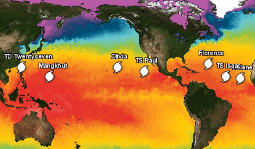 https://twitter.com/wunderground/sta...38485573312512Tropical overload! On top of #Florence, we're tracking #Helene, #Isaac, #Paul, #Olivia (a hurricane heading for Hawaii), and #Mangkhut (a typhoon fast approaching Guam)
-
2018-09-11 18:41 #84Member since 2006 and still can't think of a title.
- Join Date
- Oct 2006
- Posts
- 25,397
- BG Level
- 10
- FFXIV Character
- Acanis Lindri
- FFXIV Server
- Midgardsormr
- FFXI Server
- Bismarck
- WoW Realm
- Kil'jaeden

This is why I live in a state that is on fire 365 days a year with occasional tectonic shifts.
-
2018-09-11 19:15 #85Cardiac Cat
- Join Date
- Nov 2006
- Posts
- 11,610
- BG Level
- 9
- FFXIV Character
- Airlea Ocelot
- FFXIV Server
- Balmung
- FFXI Server
- Bahamut
- WoW Realm
- Aegwynn
so to be precise that blue dot is my house. and yes, we're getting a bunch of rain tonight too. weeeee

Sent from my SM-G900P using Tapatalk
-
2018-09-11 19:15 #86Cardiac Cat
- Join Date
- Nov 2006
- Posts
- 11,610
- BG Level
- 9
- FFXIV Character
- Airlea Ocelot
- FFXIV Server
- Balmung
- FFXI Server
- Bahamut
- WoW Realm
- Aegwynn
I know, I need to charge my phone
Sent from my SM-G900P using Tapatalk
-
2018-09-11 19:23 #87Sandworm Swallows
- Join Date
- Feb 2010
- Posts
- 7,012
- BG Level
- 8
- FFXI Server
- Sylph
When did this become the Trump thread. Originally Posted by Anoat
-
2018-09-11 19:40 #88XI was, and will always be, better.
- Join Date
- Mar 2010
- Posts
- 1,653
- BG Level
- 6
- FFXIV Character
- The Patriarch
- FFXIV Server
- Hyperion
- FFXI Server
- Ramuh
wondering what the odds are on this bad boy ramping up into a cat5
-
2018-09-11 21:11 #89Duplicitous Jew with Political Aspirations
- Join Date
- Dec 2015
- Posts
- 16,473
- BG Level
- 9
I remember Hurricane Hugo, my mom was driving my older brother and I home through traffic and the highway flooded over. Driving through up to 2 feet of water, I remember hearing someone in that jam got caught in a surge and swept away. We made it out and got back home where it wasn't even raining.
Sent from my SM-G935V using Tapatalk
-
2018-09-12 02:41 #90BG Content
- Join Date
- Oct 2005
- Posts
- 62,960
- BG Level
- 10
- FFXIV Character
- Six Souls
- FFXIV Server
- Gilgamesh
- FFXI Server
- Quetzalcoatl
- WoW Realm
- Malorne
- Blog Entries
- 9
New model, looks like no matter what, the NC coast is fucked;

https://www.npr.org/2018/09/11/64659...ory-4-florence
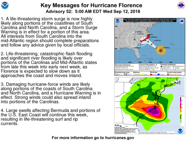
Even before it officially arrives, Florence will push tall waves far ahead of it.
"We're talking 12-foot seas stretching 300 miles away from the center," the NHC's Graham said. The large storm is also projecting tropical storm-force winds outward up to 170 miles. When it reaches inland ares, far from the coast, its high winds and heavy rains will knock down trees and wreak other havoc, according to the hurricane center.
"All the rainfall we're going to have, plus you talk about the wind — that means a lot of trees coming down, it's a lot of power outages, a lot of impacts with this system," Graham said.
The hurricane watch notice is significant because it signals the opening of a 48-hour window for the expected first arrival of tropical storm-force winds. After that point, it would be difficult for people in the storm's path to either finish preparations or flee affected areas.
On Tuesday afternoon, data from an Air Force Reserve hurricane hunter aircraft showed that Florence's sustained winds had picked up in speed again, hovering close to 140 mph. The storm is expected to strengthen again over the next day or so.
-
2018-09-12 07:54 #91Old Merits
- Join Date
- Sep 2008
- Posts
- 1,115
- BG Level
- 6
- FFXI Server
- Leviathan
we decided to stay as it looks to make landfall north of us. not looking forward to days/weeks without power at all though.
-
2018-09-12 07:59 #92Duplicitous Jew with Political Aspirations
- Join Date
- Dec 2015
- Posts
- 16,473
- BG Level
- 9
Oh that model is hitting me. Go back to some other model. I don't like this one.
Sent from my SM-G935V using Tapatalk
-
2018-09-12 08:27 #93BG Content
- Join Date
- Oct 2005
- Posts
- 62,960
- BG Level
- 10
- FFXIV Character
- Six Souls
- FFXIV Server
- Gilgamesh
- FFXI Server
- Quetzalcoatl
- WoW Realm
- Malorne
- Blog Entries
- 9
https://www.mprnews.org/story/2018/0...carolina-coast
Forecasters said Florence was expected to blow ashore late Thursday or early Friday, then slow down and dump 1 to 2 1/2 feet of rain that could cause flooding well inland and wreak environmental havoc by washing over industrial waste sites and hog farms.
President Trump declared states of emergency for North and South Carolina and Virginia, opening the way for federal aid. He said the federal government is "absolutely, totally prepared" for Florence.
All three states ordered mass evacuations along the coast. But getting out of harm's way could prove difficult.
Florence is so wide that a life-threatening storm surge was being pushed 300 miles ahead of its eye, and so wet that a swath from South Carolina to Ohio and Pennsylvania could get deluged.
The coastal surge from Florence could leave the eastern tip of North Carolina under more than 9 feet of water in spots, projections showed.
One trusted computer model, the European simulation, predicted more than 45 inches in parts of North Carolina. A year ago, people would have laughed off such a forecast, but the European model was accurate in predicting 60 inches for Hurricane Harvey in the Houston area, so "you start to wonder what these models know that we don't," University of Miami hurricane expert Brian McNoldy said.
Florence's projected path includes half a dozen nuclear power plants, pits holding coal-ash and other industrial waste, and numerous hog farms that store animal waste in huge lagoons. Duke Energy spokesperson Ryan Mosier said operators would begin shutting down nuclear plants at least two hours before hurricane-force winds arrive.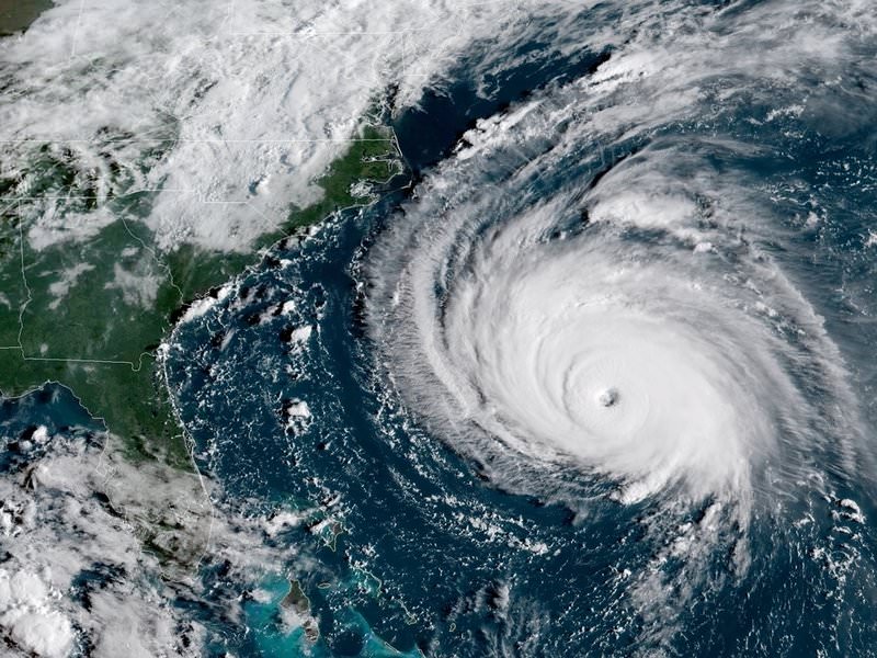
-
2018-09-12 08:41 #94BG Content
- Join Date
- Oct 2005
- Posts
- 62,960
- BG Level
- 10
- FFXIV Character
- Six Souls
- FFXIV Server
- Gilgamesh
- FFXI Server
- Quetzalcoatl
- WoW Realm
- Malorne
- Blog Entries
- 9
https://www.npr.org/2018/09/12/64700...-130-mph-winds Originally Posted by Zealot
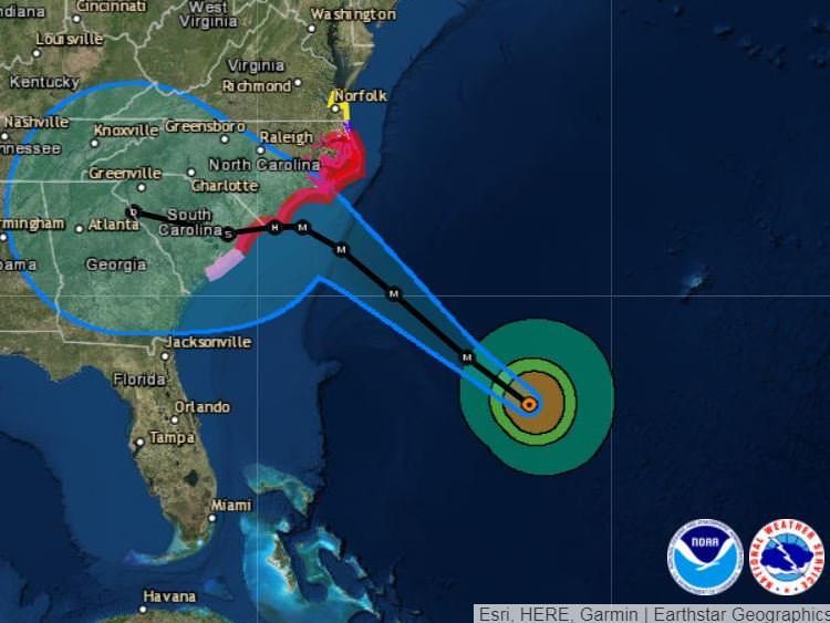
Forecasters have adjusted Hurricane Florence's predicted path, saying that after it makes landfall, it will likely take a more southerly route than had previously been expected. Rather than pushing up toward western Virginia, the storm's center is now predicted to move across the middle of South Carolina.
For a swathe of the North Carolina shore from Cape Fear to Cape Lookout, the storm surge could range from 9-13 feet, the NHC said. In Myrtle Beach, S.C., and nearby areas, the surge could hit 6-9 feet.
As of 8 a.m. ET, Florence was 530 miles southeast of Cape Fear, N.C., moving west-northwest at 17 mph, the National Hurricane Center said.
-
2018-09-12 08:45 #95Duplicitous Jew with Political Aspirations
- Join Date
- Dec 2015
- Posts
- 16,473
- BG Level
- 9
Phew, thank you.
Sent from my SM-G935V using Tapatalk
-
2018-09-12 08:48 #96
- Join Date
- Oct 2006
- Posts
- 21,428
- BG Level
- 10
- FFXIV Character
- Zetanio Breaux
- FFXIV Server
- Gilgamesh
- FFXI Server
- Odin

Hotlanta Airport shutting down? Gonna be a nighttttmareeeeee. So happy I don't have work travel this week.
-
2018-09-12 09:29 #97IMPERIAL CONCUBINE OF ME
Coolest Monkey In The Jungle
- Join Date
- Sep 2007
- Posts
- 21,547
- BG Level
- 10
im sure charlotte prob will too gonna be a gd nightmare for anyone trying to travel. i avoid charlotte airport like the plague when it's clear skies anyways though Originally Posted by Zetanio
-
2018-09-12 09:55 #98Cardiac Cat
- Join Date
- Nov 2006
- Posts
- 11,610
- BG Level
- 9
- FFXIV Character
- Airlea Ocelot
- FFXIV Server
- Balmung
- FFXI Server
- Bahamut
- WoW Realm
- Aegwynn
yay for me. sorry to everyone else!
Sent from my SM-G900P using Tapatalk
-
2018-09-12 10:39 #99BG Content
- Join Date
- Oct 2005
- Posts
- 62,960
- BG Level
- 10
- FFXIV Character
- Six Souls
- FFXIV Server
- Gilgamesh
- FFXI Server
- Quetzalcoatl
- WoW Realm
- Malorne
- Blog Entries
- 9
-
2018-09-12 11:02 #100Caesar Salad
- Join Date
- Nov 2009
- Posts
- 28,376
- BG Level
- 10
Catching up on the thread and reading this chain of comments made me chuckle heartily. Originally Posted by Zealot
Sent from my SAMSUNG-SM-G935A using Tapatalk
 Reply With Quote
