 XI Wiki


we are staying in raleigh unless something drastically changes, prayers up for the coast
- Navigation
+ Reply to Thread
Results 121 to 140 of 247
Thread: Hurricane Season 2018


-
2018-09-13 10:09 #121IMPERIAL CONCUBINE OF ME
Coolest Monkey In The Jungle
- Join Date
- Sep 2007
- Posts
- 21,547
- BG Level
- 10

-
2018-09-13 10:28 #122Relic Weapons
- Join Date
- Mar 2009
- Posts
- 301
- BG Level
- 4

Not sure if it's been posted yet, but here's a live cam from Kitty Hawk, NC and one from (what looks like) an off-shore rig/platform/etc.
-
2018-09-13 10:38 #123BG Content
- Join Date
- Oct 2005
- Posts
- 62,966
- BG Level
- 10
- FFXIV Character
- Six Souls
- FFXIV Server
- Gilgamesh
- FFXI Server
- Quetzalcoatl
- WoW Realm
- Malorne
- Blog Entries
- 9

https://www.nhc.noaa.gov/
Hurricane Florence Intermediate Advisory Number 56A
NWS National Hurricane Center Miami FL AL062018
800 AM EDT Thu Sep 13 2018
…SQUALLY RAIN BANDS WITH TROPICAL-STORM-FORCE WINDS MOVING ONSHORE
OF THE OUTER BANKS OF NORTH CAROLINA…
…LIFE-THREATENING STORM SURGE AND RAINFALL EXPECTED…
SUMMARY OF 800 AM EDT…1200 UTC…INFORMATION
———————————————-
LOCATION…33.1N 75.1W
ABOUT 170 MI…275 KM ESE OF WILMINGTON NORTH CAROLINA
ABOUT 220 MI…355 KM E OF MYRTLE BEACH SOUTH CAROLINA
MAXIMUM SUSTAINED WINDS…110 MPH…175 KM/H
PRESENT MOVEMENT…NW OR 315 DEGREES AT 12 MPH…20 KM/H
MINIMUM CENTRAL PRESSURE…956 MB…28.23 INCHES
WATCHES AND WARNINGS
——————–
CHANGES WITH THIS ADVISORY:
None.
SUMMARY OF WATCHES AND WARNINGS IN EFFECT:
A Storm Surge Warning is in effect for…
* South Santee River South Carolina to Duck North Carolina
* Albemarle and Pamlico Sounds, including the Neuse and Pamlico
Rivers
A Storm Surge Watch is in effect for…
* Edisto Beach South Carolina to South Santee River South Carolina
* North of Duck North Carolina to the North Carolina/Virginia border
A Hurricane Warning is in effect for…
* South Santee River South Carolina to Duck North Carolina
* Albemarle and Pamlico Sounds
A Hurricane Watch is in effect for…
* Edisto Beach South Carolina to South Santee River South Carolina
A Tropical Storm Warning is in effect for…
* North of Duck North Carolina to Cape Charles Light Virginia
* Chesapeake Bay south of New Point Comfort
Interests elsewhere in the southeastern and mid-Atlantic states
should monitor the progress of Florence.
A Storm Surge Warning means there is a danger of life-threatening
inundation, from rising water moving inland from the coastline. For
a depiction of areas at risk, please see the National Weather
Service Storm Surge Watch/Warning Graphic, available at
hurricanes.gov. This is a life-threatening situation. Persons
located within these areas should take all necessary actions to
protect life and property from rising water and the potential for
other dangerous conditions. Promptly follow evacuation and other
instructions from local officials.
A Storm Surge Watch means there is a possibility of life-
threatening inundation, from rising water moving inland from the
coastline.
A Hurricane Warning means that hurricane conditions are expected
somewhere within the warning area, in this case within the next 12
to 24 hours. Preparations to protect life and property should be
nearing completion.
A Hurricane Watch means that hurricane conditions are possible
within the watch area. A watch is typically issued 48 hours
before the anticipated first occurrence of tropical-storm-force
winds, conditions that make outside preparations difficult or
dangerous.
A Tropical Storm Warning means that tropical storm conditions are
expected somewhere within the warning area.
For storm information specific to your area, including possible
inland watches and warnings, please monitor products issued by your
local National Weather Service forecast office.
DISCUSSION AND OUTLOOK
———————-
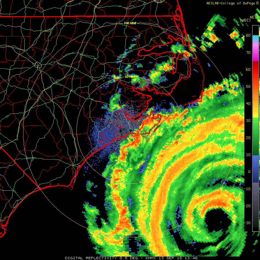
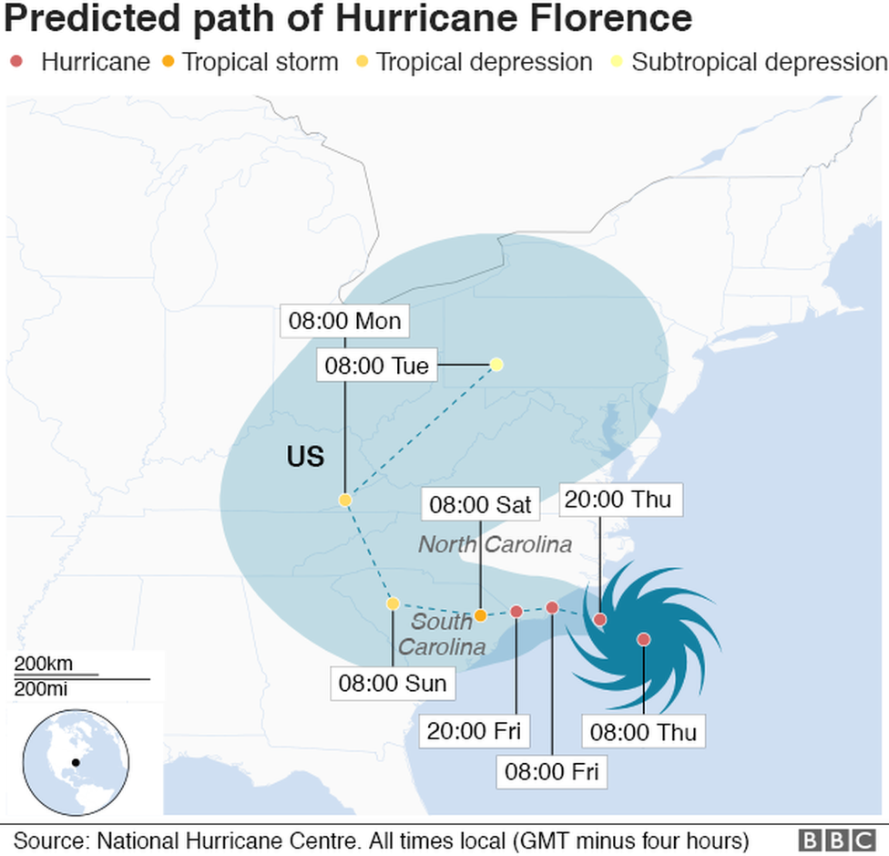
At 800 AM EDT (1200 UTC), the center of the eye of Hurricane
Florence was located by an Air Force Reserve reconnaissance aircraft
and NOAA Doppler weather radars to be near latitude 33.1 North,
longitude 75.1 West. Florence is moving slower toward the northwest
at about 12 mph (20 km/h). This general motion, accompanied by a
further decrease in forward speed, is expected to continue through
today. A turn to the west-northwest and west at an even slower
forward speed is expected tonight and Friday, and a slow
west-southwestward motion is forecast Friday night and Saturday. On
the forecast track, the center of Florence will approach the coasts
of North and South Carolina later today, then move near or over the
coast of southern North Carolina and eastern South Carolina in the
hurricane warning area tonight and Friday. A slow motion over
eastern South Carolina is forecast Friday night through Saturday
night.
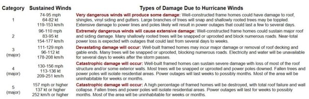
Maximum sustained winds are near 110 mph (175 km/h) with higher
gusts. Little change in strength is expected before the center
reaches the coast, with weakening expected after the center moves
inland.
Florence is a large hurricane. Hurricane-force winds extend outward
up to 80 miles (130 km) from the center and tropical-storm-force
winds extend outward up to 195 miles (315 km).
The estimated minimum central pressure based on reports from the
the aircraft is 956 mb (28.23 inches).
HAZARDS AFFECTING LAND
———————-
STORM SURGE: The combination of a dangerous storm surge and the
tide will cause normally dry areas near the coast to be flooded by
rising waters moving inland from the shoreline. The water has the
potential to reach the following heights above ground if peak surge
occurs at the time of high tide…
Cape Fear NC to Cape Lookout NC, including the Neuse, Pamlico,
Pungo, and Bay Rivers…9-13 ft
North Myrtle Beach SC to Cape Fear NC…6-9 ft
Cape Lookout NC to Ocracoke Inlet NC…6-9 ft
South Santee River SC to North Myrtle Beach SC…4-6 ft
Ocracoke Inlet NC to Salvo NC…4-6 ft
Salvo NC to North Carolina/Virginia Border…2-4 ft
Edisto Beach SC to South Santee River SC…2-4 ft
The deepest water will occur along the immediate coast in areas of
onshore winds, where the surge will be accompanied by large and
destructive waves. Surge-related flooding depends on the relative
timing of the surge and the tidal cycle, and can vary greatly over
short distances. For information specific to your area, please see
products issued by your local National Weather Service forecast
office.
RAINFALL: Florence is expected to produce heavy and excessive
rainfall in the following areas…
Coastal North Carolina into far northeastern South Carolina…20 to
30 inches, isolated 40 inches. This rainfall would produce
catastrophic flash flooding and prolonged significant river
flooding.
Rest of South and North Carolina into southwest Virginia…6 to 12
inches, isolated 24 inches.
WIND: Hurricane conditions are expected to reach the coast within
the hurricane warning area this evening or early Friday. Winds are
expected to first reach tropical storm strength by later this
morning or early this afternoon, making outside preparations
difficult or dangerous. Preparations to protect life and property
should be nearing completion.
TORNADOES: A few tornadoes are possible in eastern North Carolina
through Friday.
SURF: Swells generated by Florence are affecting Bermuda, portions
of the U.S. East Coast, and the northwestern and central Bahamas.
These swells are likely to cause life-threatening surf and rip
current conditions. Please consult products from your local weather
office.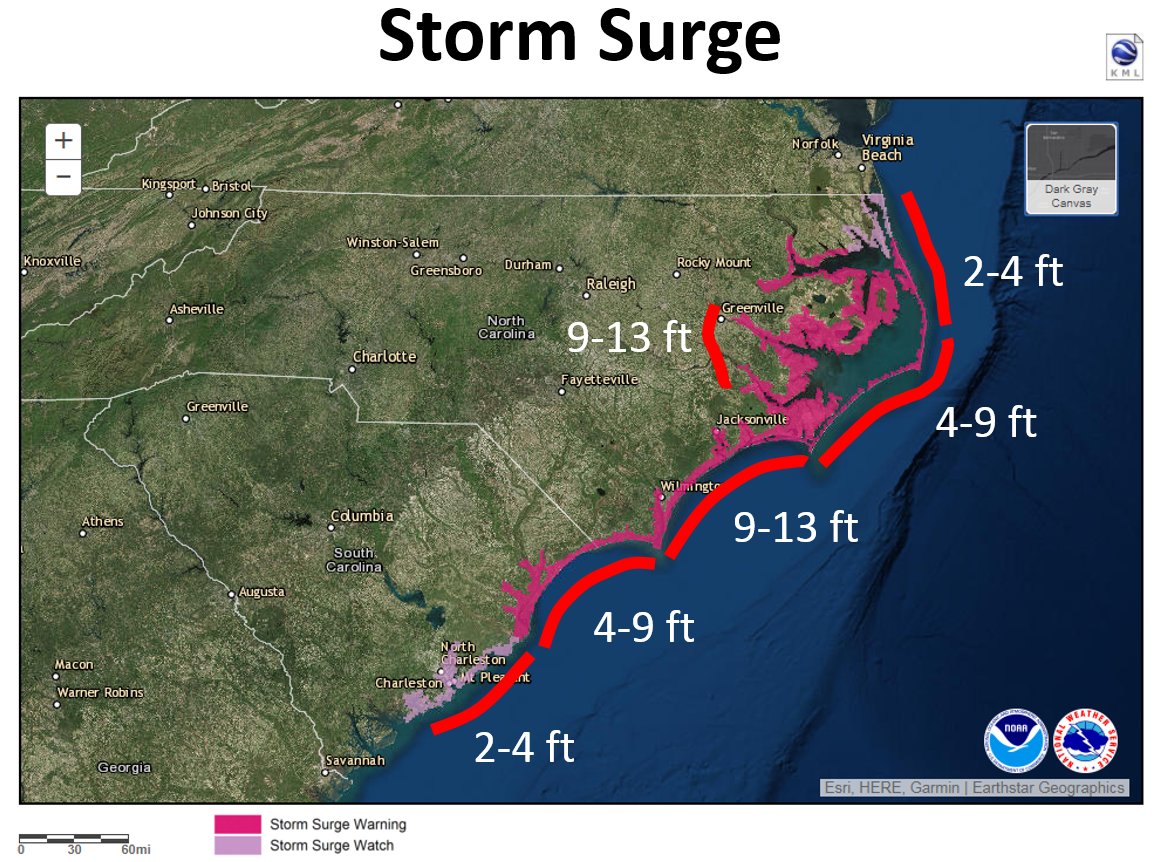

-
2018-09-13 11:57 #124Black Belt
- Join Date
- Mar 2008
- Posts
- 5,917
- BG Level
- 8
- FFXIV Character
- Cyn Dane
- FFXIV Server
- Hyperion
- FFXI Server
- Valefor
Well it looks like it's doing contortions to spare us from the worst of the storm anyways. I'm sure Capital blvd and the Crabtree Creek area will be a total fucking disaster either way though. Originally Posted by Day

-
2018-09-13 12:50 #125BG Content
- Join Date
- Oct 2005
- Posts
- 62,966
- BG Level
- 10
- FFXIV Character
- Six Souls
- FFXIV Server
- Gilgamesh
- FFXI Server
- Quetzalcoatl
- WoW Realm
- Malorne
- Blog Entries
- 9
New day new path;
-
2018-09-13 13:40 #126
- Join Date
- Oct 2006
- Posts
- 21,429
- BG Level
- 10
- FFXIV Character
- Zetanio Breaux
- FFXIV Server
- Gilgamesh
- FFXI Server
- Odin

-
2018-09-13 13:41 #127
Sweaty Dick Punching Enthusiast
- Join Date
- Mar 2010
- Posts
- 21,403
- BG Level
- 10
- FFXI Server
- Quetzalcoatl
Two things I love from the Weather Channel’s 24/7 coverage—sending some poor schmuck to stand near the beach in North Carolina and do a live report getting battered by winds and rain. Secondly their “Moses” graphic explaining the dangers of storm surge height. You’ll know it when you see it.
-
2018-09-13 13:41 #128BG Content
- Join Date
- Oct 2005
- Posts
- 62,966
- BG Level
- 10
- FFXIV Character
- Six Souls
- FFXIV Server
- Gilgamesh
- FFXI Server
- Quetzalcoatl
- WoW Realm
- Malorne
- Blog Entries
- 9
Video from Cape Hatteras Pier Drive in NC (4ish hours ago) - https://twitter.com/jeffhampton56/st...42850787717120
-
2018-09-13 13:48 #129Relic Weapons
- Join Date
- Mar 2009
- Posts
- 301
- BG Level
- 4
https://www.cnn.com/specials/live-video-1 too Originally Posted by Zetanio
-
2018-09-13 15:01 #130IMPERIAL CONCUBINE OF ME
Coolest Monkey In The Jungle
- Join Date
- Sep 2007
- Posts
- 21,547
- BG Level
- 10
here's 1 more this is where my vacation is booked in a week and a half RIP https://www.wral.com/weather/video/17840703/
-
2018-09-13 15:03 #131BG Content
- Join Date
- Oct 2005
- Posts
- 62,966
- BG Level
- 10
- FFXIV Character
- Six Souls
- FFXIV Server
- Gilgamesh
- FFXI Server
- Quetzalcoatl
- WoW Realm
- Malorne
- Blog Entries
- 9
Aside from the wind, that doesn't look so bad. Originally Posted by Day
-
2018-09-13 15:17 #132Duplicitous Jew with Political Aspirations
- Join Date
- Dec 2015
- Posts
- 16,481
- BG Level
- 9
Rain has begun making landfall. Whatever this hurricane is going to do it's going to start doing it now.
-
2018-09-13 15:37 #133IMPERIAL CONCUBINE OF ME
Coolest Monkey In The Jungle
- Join Date
- Sep 2007
- Posts
- 21,547
- BG Level
- 10
theres some good ole boys standing out there on this one right now lol Originally Posted by Lucki
edit; cam moved D:
-
2018-09-13 16:03 #134BG Content
- Join Date
- Oct 2005
- Posts
- 62,966
- BG Level
- 10
- FFXIV Character
- Six Souls
- FFXIV Server
- Gilgamesh
- FFXI Server
- Quetzalcoatl
- WoW Realm
- Malorne
- Blog Entries
- 9
https://twitter.com/bhensonweather/s...08676605739009
Florence is packing 60% as much Kinetic Energy as Irma, Ike, & Katrina.
Sandy was a Cat 1 when it made landfall and caused a lot of damage. Florence still on track to be a Cat 2 landfall.
Storm is still expected to stall out over the Carolinas for 24hrs+.
-
2018-09-13 17:18 #135Old Merits
- Join Date
- Sep 2008
- Posts
- 1,115
- BG Level
- 6
- FFXI Server
- Leviathan
pretty calm here in southport, some rain and wind but very mild still
-
2018-09-13 18:33 #136BG Content
- Join Date
- Oct 2005
- Posts
- 62,966
- BG Level
- 10
- FFXIV Character
- Six Souls
- FFXIV Server
- Gilgamesh
- FFXI Server
- Quetzalcoatl
- WoW Realm
- Malorne
- Blog Entries
- 9

If you want good updates on the storm, search the ncwx hashtag on twitter - https://twitter.com/hashtag/ncwx?f=t...fault&src=hash
the hurricaneflorence hashtag is all memes and conspiracy theories.
-
2018-09-13 19:16 #137BG's #1 Hatsune Miku fan!
- Join Date
- Dec 2009
- Posts
- 7,513
- BG Level
- 8
It doesn't look like it's going to be as bad as they predicted but still all the barrier islands and maybe even Greenville are going to be under water.
It always amazes me just how massive hurricanes can get. Originally Posted by 6souls
-
2018-09-13 22:17 #138
Sweaty Dick Punching Enthusiast
- Join Date
- Mar 2010
- Posts
- 21,403
- BG Level
- 10
- FFXI Server
- Quetzalcoatl
If you really want some hurricane wtf, look up the Great Red Spot on Jupiter. It’s a hurricane that has been ongoing for hundreds of years, first confirmed observed in the 1800s and possibly as early as the 1600s. The Spot is 1.3 times the size of planet Earth. Originally Posted by Outlaw
-
2018-09-13 23:44 #139
Sweaty Dick Punching Enthusiast
- Join Date
- Mar 2010
- Posts
- 21,403
- BG Level
- 10
- FFXI Server
- Quetzalcoatl
Downgraded to Cat 1 as of the 11pm forecast now that it has made landfall.
-
2018-09-13 23:47 #140The Optimistic Asshole
Sweaty Dick Punching Enthusiast
- Join Date
- Aug 2005
- Posts
- 27,571
- BG Level
- 10
- FFXIV Character
- Tyche Six
- FFXIV Server
- Tonberry
Looks like Charleston may be spared the worst of it. I may actually get to vacation there in a few weeks without needing waders.
 Reply With Quote